How the treasured landscapes of the Bannau Brycheiniog came to be has been revealed in ‘The Land of the Beacons Way’, a new book by geology writer Dilys Harlow. Starting along the well-known and loved 100 mile trail of the Beacons Way, the book opens a window on the deep history of the National Park, unearthing its secrets to help visitors and residents understand how this unique place developed into what it is today.
The new book, published in October 2014 by the South Wales Geologists’ Association, is the culmination of over two years’ work by Dilys unearthing the geological development of the national park and piecing together its story. Its 124 colourfully illustrated pages provide an invaluable guide for anyone wishing to delve into the history of this protected landscape. Conceived as a guide for walkers following the Beacons Way – a walking route of almost 100 miles length from the ‘Holy Mountain’ (or The Skirrid) in the east to Bethlehem in the west – the finished product is much more than that. It can be enjoyed as much from the comfort of an armchair as from the trodden path; maps and colour photos steer the mind of the reader through time and space.
Author Dilys Harlow brought to the task her many years’ familiarity with the area through leading guided walks for the Bannau Brycheiniog Park Society. She said of the book, “I hope it can open others’ eyes to the rich geological legacy that this national park can boast. Once you start digging beneath the surface, there seems to be no end of interesting tales to be unearthed. We all have our favourite corners of the national park and I’ve been lucky to have an excuse to get to know many others in the course of writing this guide.’’
Welcoming the guide on the part of the Bannau Brycheiniog National Park Authority, Alan Bowring, Geopark Development Officer said: “Fforest Fawr Geopark is proud to be associated with this publication: the effort which Dilys Harlow has put into researching and writing this guide is really very considerable. What has emerged fills a niche in the market between the simple leaflets on the one hand and academic tomes on the other. It reveals to the interested visitor a dazzling history of colliding continents and tropical seas, baking deserts and grinding glaciers. Dilys takes us on an intellectual journey through time and space; some of the stories are well-known, others less so. Our Old Red Sandstone mountains and our limestone caves, our striking gritstone edges and our mysterious moraines; all have a tale to tell and Dilys gives them words. The book will appeal to walkers, historians, geologists and others who have a passion for the National Park and want to discover more about this special place. As far as we’re aware this is the first general guide to the area’s rocky foundations so we’re delighted that it’s now available in all our Visitor Centres.”
The book costs £7.95 and is available from the National Park Visitor Centre near Libanus, Brecon and from other Tourist Information Centres at Abergavenny, Llandovery, Talgarth, Brynaman, Pontneddfechan and Crickhowell. It can also be purchased from the Geologists’ Association South Wales Group, National Museum of Wales, Cardiff CF10 3NP. Cheques should be made payable to the Geologists’ Association South Wales Group.
-ENDS-
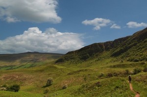
Pictures taken from the book:
Fig. Craig Cerrig Gleisiad – a landslide and a glacier sculpted the Old Red Sandstone rocks into the cwm at Craig Cerrig-Gleisiad – taken by Andy Kendall.